


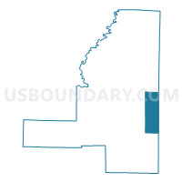
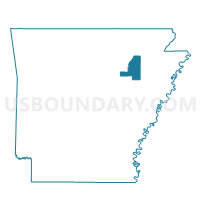
Pennington Balch Voting District, Jackson County, Arkansas
About
Outline

Summary
| Unique Area Identifier | 526778 |
| Name | Pennington Balch Voting District |
| County | Jackson County |
| State | Arkansas |
| Area (square miles) | 27.40 |
| Land Area (square miles) | 27.18 |
| Water Area (square miles) | 0.22 |
| % of Land Area | 99.20 |
| % of Water Area | 0.80 |
| Latitude of the Internal Point | 35.55262110 |
| Longtitude of the Internal Point | -91.06073940 |
Maps

Graphs
Select a template below for downloading or customizing gragh for Pennington Balch Voting District, Jackson County, Arkansas


Neighbors
Neighoring Voting District (by Name) Neighboring Voting District on the Map
- Amagon Voting District, Jackson County, AR
- Beedeville Voting District, Jackson County, AR
- Dobson Pitts Voting District, Poinsett County, AR
- Grubbs Voting District, Jackson County, AR
- Owen Fisher Voting District, Poinsett County, AR
- Owen Waldenburg Voting District, Poinsett County, AR
- West Prairie TWP Voting District, Poinsett County, AR
Top 10 Neighboring County Subdivision (by Population) Neighboring County Subdivision on the Map
- West Prairie township, Poinsett County, AR (894)
- Owen township, Poinsett County, AR (600)
- Grubbs township, Jackson County, AR (572)
- Cow Lake township, Jackson County, AR (377)
- Richwoods township, Jackson County, AR (341)
- Dobson township, Poinsett County, AR (170)
Top 10 Neighboring Unified School District (by Population) Neighboring Unified School District on the Map
- Newport School District, AR (11,706)
- Jackson County School District, AR (4,609)
- Weiner School District, AR (1,562)
Top 10 Neighboring State Legislative District Lower Chamber (by Population) Neighboring State Legislative District Lower Chamber on the Map
Top 10 Neighboring State Legislative District Upper Chamber (by Population) Neighboring State Legislative District Upper Chamber on the Map
Top 10 Neighboring 111th Congressional District (by Population) Neighboring 111th Congressional District on the Map
Top 10 Neighboring Census Tract (by Population) Neighboring Census Tract on the Map
Top 10 Neighboring 5-Digit ZIP Code Tabulation Area (by Population) Neighboring 5-Digit ZIP Code Tabulation Area on the Map
- 72112, AR (11,467)
- 72479, AR (1,489)
- 72347, AR (711)
- 72429, AR (427)
- 72431, AR (401)
- 72005, AR (248)